look_park_map.pdf-----> LOAD FESTIVAL MAP <-----
Directions to the major sites and pavilions in the Park
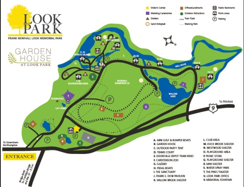
DIRECTIONS TO THE PARK:
I-91 From Springfield: Take Exit 25 and go straight ahead to Damon Road, then onto Bridge Road.
I-91 from Greenfield: Take Exit 26 to light and turn right onto Bridge Road.
General Park Roads: The Park is a one-way circle loop road of approximately 1.2 miles. At the bottom of the hill from the entry booth the road splits. You must bear to the right. The speed limit on all Park roads is 15 miles per hour. There are speed bumps throughout the Park which you should approach at a lower rate of speed.
Visitor’s Center: The Visitor’s Center is the first building on the right. (For the Festival, there is no parking in this area. However, the ATM is located in this building).
Festival Entry Area: The ticket sales and admission is located on the road after the Visitor's Center. This is staffed by volunteers from River Valley Counseling Center.
General Picnic Areas: Picnic tables are numbered 1 – 72, and each site has clearly marked signs. The sites begin to the right of the Dow Pavilion with number 72 and count down to number 1 in the Playground Area. If they are free, these tables are available for Festival attendees.
Pavilions:
Dow Pavilion: The Dow Pavilion is approximately 4/10’s of the way around the Park. As you proceed around the loop road you will see Willow Lake on your left. Just after you come down the hill by the lake you will see the Dow Pavilion on your right.
Willowbrook Shelter: The Willowbrook Shelter is located on the right approximately 2/3 of the way around the Park. To find the Willowbrook Shelter watch the picnic site numbers. They count down from 72. The Willowbrook Shelter is located just after number 53.
The Westwood Shelter and Duckbrook Shelter: These shelters are on the right approximately ¾ of the way around the Park. They are located behind the Sweet Shop, where there is generally parking available. Walk over the stone bridge and bear to the right for the Westwood Shelter and the Duckbrook Shelter.
The Playground Shelter, Mini Shelter: These three areas are on the right approximately 8/10’s of the way around the Park. They are not available for use by Festival attendees.
Festival Parking:
General parking is located on the main ball field. Park employees will direct you to that area.